
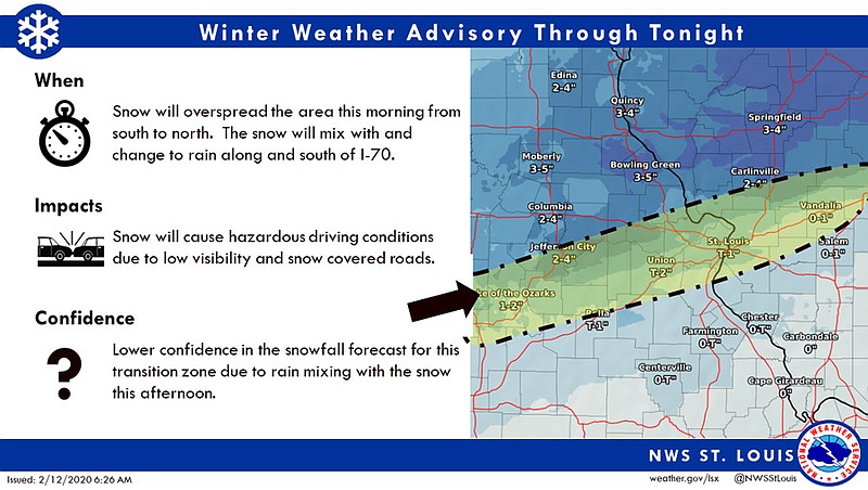
The National Weather Service in St. Louis has issued a Winter Weather Advisory for Wednesday affecting Mid-Missouri, including Boone, Callaway, Cole, Miller, Moniteau, Morgan and Osage counties, among others.
The Winter Weather Advisory is in effect from 9 a.m.-midnight Wednesday.
Snow accumulation of up to 4 inches, possibly mixed with rain, is in the forecast Wednesday for the advisory area, with the high temperature in the mid-30s. The chance of precipitation is near 100 percent, according to the NWS.
Wednesday night, the forecast calls for blustery, cold weather with snow and possible rain in the evening and a chance of up to 2 inches of snow after midnight.
The NWS issued the following statement:
...WINTER WEATHER ADVISORY NOW IN EFFECT FROM 9 AM THIS MORNING TO 3 AM CST THURSDAY...
WHAT... Snow expected. Total snow accumulations of 3 to 4 inches.
WHERE... Portions of central, east central and northeast Missouri and southwest Illinois.
WHEN...From 9 AM this morning to 3 AM CST Thursday.
IMPACTS... Plan on slippery road conditions. The hazardous conditions could impact the evening commute.
PRECAUTIONARY/PREPAREDNESS ACTIONS... A Winter Weather Advisory for snow means that periods of accumulating snow will primarily cause travel difficulties. Roads may rapidly become slippery once the snow begins, so motorists should plan for a slower than normal trip. Be especially alert when approaching bridges, overpasses, and curves.
Additional resources:
School and weather-related announcements for Wednesday, Feb. 12, 2020
MoDOT statewide traveler information map
Jefferson City street condition map
Columbia Regional Airport flight status